WASHINGTON FOREST PROTECTION ASSOCIATION
Fires in Washington State: Fire Management and Prevention Strategies
Fires in Washington State: Understanding, Managing, and Preventing Wildfire Risks
Wildfires in Washington State pose significant risks to communities, ecosystems, and the economy. Understanding, managing, and preventing these fires is crucial for safeguarding lives, property, and the environment. Effective wildfire management requires a collaborative approach involving state agencies, local communities, and private stakeholders.
Washington Fire Map
To stay informed and prepared, use the interactive fire map below, which shows current fire locations, sizes, and containment status. This tool is essential for monitoring wildfire activity and ensuring safety during fire season. For more real-time information, use the WA DNR Wildfire Intel Dashboard.
During fire season, this web-based interactive map by the Northwest Interagency Coordination Center (NWCC) is updated daily with current fire perimeters and locations—access detailed information about these NW fires, both current and historical. Toggle layers and off, create custom maps and presentations, perform simple queries, and much more.
A “Large” Fire, as defined by the National Wildland Coordinating Group, is any wildland fire in timber of ≥100 acres or≥300 acres in grasslands/rangelands or has an Incident Management Team assigned to it. Information received from the National ICS-209 incident reporting database for large fires is updated each morning and shows what has been reported by the Incident Commander the previous day at 7:00 PM. The information shown for each fire incident on the current day may not reflect changes made since the ICS-209 input.
Importance of Wildfire Management
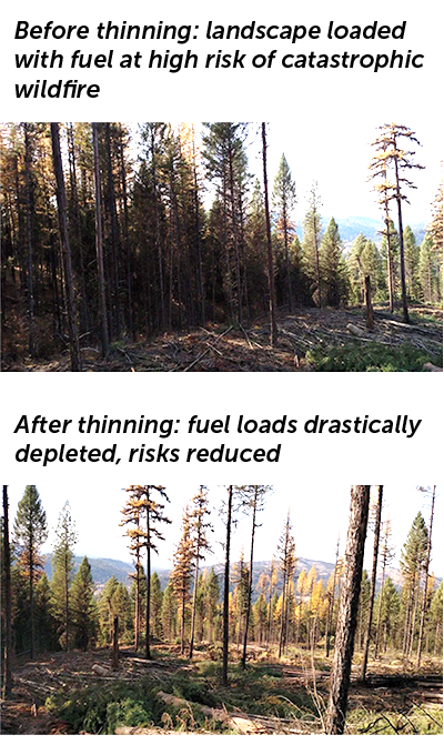
Washington’s diverse landscapes, from dense forests to arid plains, are susceptible to wildfires, particularly during dry, windy conditions. Unmanaged forests with dense underbrush and dead vegetation increase the risk and intensity of fires. Active forest management, including thinning, prescribed burns, and strategic harvesting, reduces fuel loads and promotes healthier, more resilient forests.
Actions Private Forest Landowners Take to Prevent Wildfire
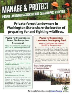
Private forest landowners in Washington State share the burden of preparing for, and fighting, wildfires in our state. This is done through the Forest Fire Protection Assessments and Landowner Contingency Fund.
Forest Fire Protection Assessment (FFPA) Pays for Preparedness
Protection Costs are Shared Between Landowners and the State
Protection costs are statutorily required to be equitably shared between state contributions and landowners (see RCW 76.04.167). Suppression costs are paid with the state general fund and other sources. However, the (landowner-funded) Landowner Contingency Fund pays for fire suppression costs on private forest lands where the fire was started through normal landowner operations (see RCW 76.04.630).
The Legislature Sets the FFPA Role
The FFPA is an assessment on forest landowners collected by the county treasurers through the property tax statement (see RCW 76.04.610). It has two statutorily set components: a flat parcel charge (currently $17.50/parcel) and an acreage charge (currently $0.27/acre). The acreage charge is assessed only on parcels in excess of fifty acres. In other words, the first fifty acres of a parcel are not assessed the acreage charge. (see RCW 76.04.610(1)(a)) Nearly 472,000 private parcels (nearly 9.5 million acres) are assessed the FFPA on the owner’s property tax statement. Another three million acres owned by the state or other public also pay the FFPA but are direct billed by DNR.
About $10.5 million is raised through the FFPA on public and private lands.
County Treasurers keep fifty cents per parcel to cover collection costs; the net to the protection program is $17/parcel (see RCW 76.04.610(5)). In each county, if a landowner owns more than one parcel that is less than fifty acres in size, then the landowner may apply for a refund (see RCW 76.04.610(2)). Refunds are not allowed for parcels greater than fifty acres in size.
Landowner Contingency Fund (LOCF) Assessed on Landowners Pays for Fire Suppression
The LOC Fund pays for fire suppression costs on private forest lands where the fire was started through normal landowner operations. If the origin of the fire was other than normal landowner operations, the suppression costs are to be recovered by the DNR and deposited back into the LOC Fund. See RCW 76.04.630. The DNR sets the assessment rate in order to maintain a statutorily required minimum LOC Fund balance of $3 million.
The assessments are similar in nature to the FFPA and also appear on the property tax statement. The LOC Fund assessments are sometimes consolidated with the FFPA assessment so they appear as a single assessment on the property tax statement. Currently the LOC Fund assessment is $6.00/parcel and $0.15/acre for acres in a parcel in excess of fifty acres.
About $4.2 million per year flows into the LOCF from assessments.
Collaborative Strategies

State and Local Agencies
Effective wildfire response and prevention require coordination between the Department of Natural Resources (DNR), local fire districts, and other state agencies.

Community Involvement
Public education and community programs, such as Firewise, empower residents to create defensible spaces around their properties, reducing wildfire risks.

Stakeholder Partnerships
Collaborations with organizations like the WFPA and private landowners help implement sustainable forest management practices and support legislative efforts to fund wildfire prevention and response initiatives.
Understanding Wildfire Risks
Wildfires in Washington State are influenced by a combination of natural and human factors. Understanding these risks is essential for effective prevention and management.
Factors Contributing to Wildfires in Washington
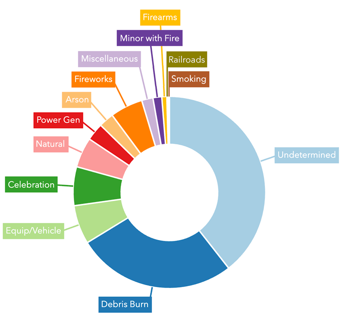
2024 Wildfire Causes on WA DNR Lands as of 7/24/24.
For more fire statistics visit DNR Wildfire Intel Dashboard.
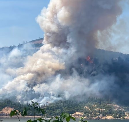
July 2023 – The Tunnel 5 Fire, fueled by dry vegetation and strong winds, races up a hillside in Underwood, WA. The fire destroyed ten structures and threatened about 250 more. Over 1,000 residents were impacted by the fire and Level 3 “Go Now” evacuation orders.
Causes of Wildfire Ignition:
While both human actions and natural occurrences can spark wildfires in Washington, human activities are the leading cause of these destructive blazes.
- Human Activities: The most common human-related cause is debris burning, which can get out of control quickly if not properly managed. Celebrations, fireworks, and the use of equipment/vehicles also contribute significantly to wildfire ignitions.
- Natural Causes: While less frequent, natural events also contribute to wildfires in the state. Lightning strikes, accounting for 5.1% of cases, are the most common natural cause. The intense heat from lightning can easily ignite dry vegetation, especially during drought periods.
Weather Patterns:
- Drought: Extended periods of drought dry out vegetation, making it more flammable.
- Wind: High winds can rapidly spread fires and make them more difficult to control.
Fuel Types:
- Vegetation: Dense underbrush, dead trees, and dry grasses act as fuel, feeding wildfires.
- Topography: Steep slopes can accelerate the spread of wildfires, while valleys can funnel wind and increase fire intensity.
Vulnerable Areas:
- Wildland-Urban Interface (WUI): Areas where homes and other structures are in close proximity to wildlands are particularly at risk.
Impact of Wildfires on Washington's Forests
Human Costs:
Loss of Life and Injuries: Wildfires pose significant risks to human life. In 2015, three firefighters were tragically killed in Okanogan County, and in 2023, two people died in Spokane County.
Health Impacts: Smoke and air pollution from wildfires can cause respiratory problems and other health issues in affected populations.
Ecological Effects:
Forests and Wildlife: Wildfires can destroy habitats, alter ecosystems, and threaten endangered species.
Watersheds: Fires can affect water quality by increasing sediment and ash in streams and rivers.
Economic Costs:
Firefighting and Recovery: The costs of firefighting efforts and post-fire recovery can be substantial.
Timber and Property Losses: Wildfires can destroy valuable timber resources and private property, impacting local economies.
Post-Fire Debris Flows: After a fire, burned soil can no longer absorb water, leading to rapid runoff and erosion. This can result in destructive debris flows, especially during heavy rains, posing further risks to communities and ecosystems. Learn more about post-fire debris flows.
Climate Costs:
Wildfire Emissions: Healthy forests act as carbon sinks, sequestering CO2 from the atmosphere. Wildfires release that stored carbon back into the atmosphere, contributing to climate change.
Fire Management and Prevention Strategies
Effective fire management and prevention strategies are crucial for mitigating wildfire risks and promoting forest health in Washington State. These strategies include prescribed burns, forest management practices, and resources for homeowners and landowners.
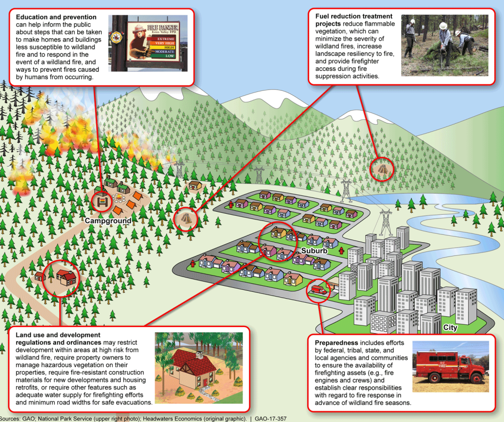
Fuel reduction, fire preparedness, prevention, and education work together to reduce wildfire risks.
Forest Management Practices
Thinning, Brush Removal, and Other Practices
Forest management practices aim to reduce wildfire risk and enhance forest resilience. Key practices include:
- Thinning: Selectively removing trees to decrease density and reduce competition for resources.
- Brush Removal: Clearing underbrush and dead vegetation to lower fuel loads.
- Pruning: Trimming lower branches to prevent ground fires from reaching the canopy.
Sustainable Forestry's Role in Creating Resilient Forests
Sustainable forestry involves managing forests to maintain their health, productivity, and biodiversity. Practices such as selective logging, reforestation, and maintaining natural fire regimes create more resilient forests to wildfires and other disturbances.
Homeowner and Landowner Resources
Firewise Principles for Creating Defensible Space Around Homes
Firewise is a nationwide program that provides guidelines for homeowners to reduce wildfire risks. Key principles include:
- Creating Defensible Space: Clearing flammable vegetation within a specific radius around homes and structures.
- Using Fire-Resistant Materials: Incorporating non-combustible building materials in home construction and maintenance.
Resources and Information for Protecting Property from Wildfires
Homeowners and landowners can access various resources to protect their properties, such as:
- Firewise USA® Program: Offers tips and checklists for creating defensible space.
- Local Fire Departments: Provide guidance and support for wildfire preparedness.
- State and Federal Agencies: Offer information on wildfire risk assessments and mitigation programs.
The Role of Prescribed Fire in Forest Health
Importance of Prescribed Burns
Prescribed or controlled burns are intentional fires set under carefully controlled conditions to reduce fuel loads, such as dead vegetation and underbrush. They help decrease the intensity and spread of potential wildfires, promoting healthier forests and ecosystems.
How Prescribed Burns Are Planned and Conducted Safely
Prescribed burns are meticulously planned by fire management professionals who consider weather conditions, topography, and fuel types. Safety measures include:
- Creating firebreaks to contain the burn area.
- Monitoring weather forecasts to ensure favorable conditions.
- Having firefighting personnel and equipment on standby to manage any unexpected changes.
Conclusion: Working Together to Protect Washington's Forests
Protecting Washington’s forests from wildfires requires a collective effort from state agencies, local communities, private stakeholders, and individuals. By understanding wildfire risks, implementing effective management strategies, and utilizing available resources, we can significantly reduce the impact of wildfires on our environment, economy, and public health.
Principles for Improving Forest Health & Wildfire Policy
WFPA advocates for the following key principles to improve forest health and reduce wildfire risks:
- Fuel Reduction: Strategic thinning and clearing of dry brush, followed by controlled burns, to manage flammable material in forests.
- Early Suppression: Rapid response to wildfires to minimize their size and severity.
- Prevention Saves Property, Habitat, and Lives: Applying preventive measures across all lands to promote healthy forest conditions and prevent runaway fires.
- Post-Fire Environmental Recovery: Immediate recovery efforts to retain economic value, control soil erosion, and reduce landslide risks.
By adhering to these principles, we can enhance the resilience of Washington’s forests and protect our communities from the devastating effects of wildfires.
Show Your Support For Responsible, Science-Driven Methods For Preventing and Reducing Catastrophic Wildfires.
Proactive management can help to curb the dangers of smoke and carbon emissions created by forestland fires. We don’t have to accept catastrophic wildfires as the “new normal.”
Add Your Name Today!
"*" indicates required fields
